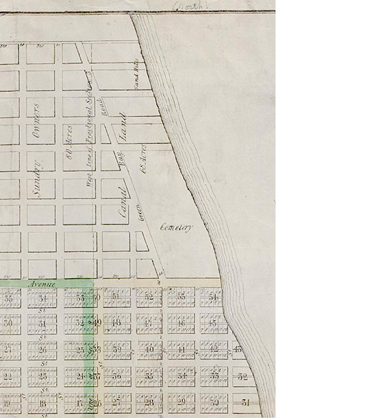
First surveyed in 1830, the Original Town of Chicago spanned the general area of today's downtown section known as "the loop." Bounded at the north by Kinzie St., south at Madison St., west at Des Plaines St., and east at State St., the town soon expanded with additions. This detail from an unsigned 1836 survey map shows a town that has expanded north to today's Division Street. In 1833, with the northern boundary of Kinzie's Addition marked at Chicago Avenue, and following a new European custom, officials established the town's first cemeteries beyond its borders. The north side burial ground extended from Chicago Avenue to Oak Street, and from Green Bay Road (today's Rush Street) to the Lake Michigan shoreline. Also along the lakeshore, the south side graveyard was situated at the southern boundary of 23rd Street. Burials elsewhere were now forbidden. By 1845, Chicago had expanded north to North Avenue, named for its designation as the northern boundary of the now-incorporated city. Similarly, Western Avenue was named for establishing the city's western boundary. Chicago's southern border remained at 23rd Street. Once the city's borders encroached and then extended beyond the cemetery at Chicago Avenue, officials established the first city-wide municipal burial ground at North Avenue. Exhumations from the earlier graveyards comprised the Chicago City Cemetery's first burials. Not all graves were removed as has been noted during modern construction, including at the 1965 building site of the John Hancock Center at Michigan Avenue between Chestnut Street and Delaware Place. See the history of the Chicago City Cemetery and its transition to today's Lincoln Park at Shifting Grounds' prequel and companion project, Hidden Truths. |
 Courtesy of the Chicago History Museum. See the entire map in the online version of the Encyclopedia of Chicago. |